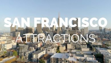
Daniel explains how to navigate the hills and valleys that make up “The Golden City”, San Francisco.
Learn more about Bright Trip at https://www.brighttrip.com/courses?utm_source=youtube&utm_medium=video&utm_campaign=san-francisco-map-explained
When most people think of San Francisco, the first thing to come to mind is the bay it’s named after. Often overlooked is the city’s other most prominent feature: the hills it’s built on. In this map breakdown, Daniel shows us how the geography of the land and its robust history shaped the city as it is today and how to find your way around.
Hillmapper Map: http://hillmapper.com/#13/map/37.79140/-122.41068/143/43
SF landmarks Map: https://sfplanning.org/resource/historic-landmarks-map
What Map breakdown do you want us to make? Let us know in the comments!
Make sure to subscribe to the channel to learn how to travel smarter.
Written, edited and animated by @DanielsimsSteiner
===== FOLLOW ON SOCIAL =====
Bright Trip Newsletter: https://mailchi.mp/brighttrip.com/signup-form
Bright Trip on IG: https://www.instagram.com/bright.trip/
Bright Trip on Pinterest: https://www.pinterest.com/brighttriptravel/
Bright Trip on Facebook: https://www.facebook.com/BrightTripTeam
Bright Trip on Twitter: https://twitter.com/trip_bright
===== ABOUT BRIGHT TRIP =====
Bright Trip creates video-based travel courses to help you travel smarter. From our location courses that visually demystify places like Tokyo, London, Costa Rica, or Cape Town to our skills courses that cover how to travel solo, with kids, or how to document your travels more effectively and efficiently – each course is created by real travelers, like you, and aims to create a community of curious travelers that are eager to travel smarter.
#brighttrip #travelguide #travelsmarter


San Francisco is one of my favorite cities and learning more about it as I made this made me wanna go back ASAP. Let me know if/how this video helps you on a visit to SF!
Why is he calling Golden Gate Park, Golden State Park?
This is an exceptional video— really, really well done. Thank you for the effort.
You definitely have skater hair.
"golden gate park" and it's way larger than Central Park in Manhattan NY.
Excellent! Almost flawless, aside from the typo at 0:35.
Potrero Hill also has streets that run north/south named after US States. Back in the 90's I used to live on Wisconsin in Protero Hill. The "numbered" streets run east/west while the "state" streets are perpendicular and run N/S.
Out in the numbered "Avenues" there is a trick to figure if the address is north of "golden state" park in the Richmond or south in the Sunset.
Three digits for the Richmond, four for the Sunset….
I live in SF.
I watched this video several weeks ago, and noted to myself the funny error of "Golden State Park." This evening I referred to it accidentally in this way to some friends. We all agreed it was better than the current "Golden Gate Park."
Your information is lacking.
1) Col. Fresno swindled the Workman family out of Alcatraz. By the way, it was called Pumpkin island before its name was switched to Alcatraz.
2) The Chinese first had a fishing village on the sea cliff area. Then rich prejudice people forced them off the sea cliffs into what is china town today.
3) Never live in the Marina district, it is built on landfill from the 1906 earthquake.
4) It is Golden Gate Park, not Golden State Park.
5) You are forgiven, go and sin no longer.
I love this video. I am a san francisco native and found some of this information to be new to me and super valuable. Thank you
The Presidio is still Federal land. It’s part of the Golden Gate National Recreation Area though it is managed by a private association, The Presidio Trust which oversees the leases and the management of the public spaces. Though part of the city of San Francisco, law enforcement is handled by Federal officers not city or state.
Really good!
As a 3rd generation San Francisco native, this interests me.
Great historic summary! I’ve lived in the Bay Area for about 10 years and still keep learning about its rich history.
To get a vivid sense of how it looked in the early 1900s, I highly recommend "San Francisco 1906 (New Version) in Color," recorded by the Miles Brothers on April 14, 1906, just four days before the earthquake.
The highly prominent horse-drawn cars were what I expected to see, but I was surprised by the large number of cable cars—not that different from today's traffic.
I would love to learn more about how the Bay Area looked during that era, especially the taverns that welcomed travelers moving between Bay Area towns.
The Ohlone people took the land from the Hokan people. Why does this video ignore that important historical fact?
East bay area resident here. VERY GOOD JOB!
GOLDEN GATE!!!
GOLDEN GATE PARK!!!
and it's actually 178 acres larger than Central Park
Did I hear, “Golden STATE Bridge”?
Nice content. Raised in Marin co just north and am an indigenous of the area. The correct pronunciation of the first local people is ow-low-nee.
Well done video. "The City" is easily the most architecturally beautiful city in the United States, you could vastly improve this video by just narrating and substitute more photos instead of your face.
Bring comfortable walking shoes. You're going to walk and eat and take tons of pictures.
Bring a windbreaker or shell to protect from a cold breeze or fog.
You may see panhandlers in the touristy areas; just shake your head slowly, avoid eye contact and walk past them.
Jean J Vioget's grid plan for Yerba Buena not perfectly aligned with true north, there is an offset of approximately 2½ degrees. Perhaps this lends a hand into the eccentric nature of San Franciscans.😊
excellent presentation. both educational and informative. A+!
wonderful video with great information
Beautiful city